Show summary Hide summary
- Record-breaking landfall: Melissa’s impact on Jamaica
- Images and video fueling global attention
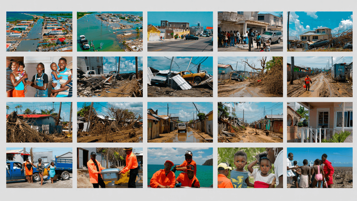
- Buildings, hospitals and power networks: widespread infrastructure damage
- On-the-ground scenes: roads blocked, rivers overrun, and overturned vehicles
- Voices from survivors: hours of terror and shaking windows
- Black River and Sangster Airport: coastal towns and travel hubs hit hard
- Regional trail: Dominican Republic, Cuba, and the Bahamas warned
- Human cost, rescues, and stories of survival
- Communication gaps and the challenge of assessing damage
- False images and viral misinformation to watch for
- Animals saved and acts of local preparation
- How to help: vetted relief organizations accepting donations
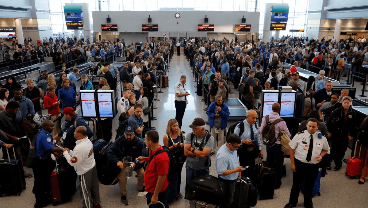
- Travelers and tourists affected
Hurricane Melissa ripped across the Caribbean this week, battering islands with unprecedented force and leaving a wake of wrecked buildings, flooded neighborhoods, and stunned survivors. As local authorities scramble to assess damage, viral footage and first-person accounts are painting a raw picture of a storm that officials say will be remembered for years.
Record-breaking landfall: Melissa’s impact on Jamaica
Meteorologists confirm Melissa made landfall on Jamaica as a Category 5 hurricane. The storm packed sustained winds near 185 mph and a central pressure around 892 millibars. Those figures mark it among the most intense hurricanes to strike the island in recorded history.
Arkansas’ Darius Acuff Jr. earns rare Kyrie Irving comp from Bill Simmons
Sean Penn awarded Oscar forged from war-damaged Ukrainian train: he skipped the ceremony
- Category: 5 at Jamaican landfall.
- Winds: Approximately 185 mph.
- Pressure: Near 892 mb, indicating extreme intensity.
Images and video fueling global attention
Satellite shots and smartphone clips showing Melissa’s clean eye and violent eyewall circulated rapidly online. Those images drew commentary from weather experts and flooded social feeds, amplifying concern and interest.
Why the visuals matter for science and public attention
Remarkably organized structure and prolonged intensification made the storm a subject of study. Visuals helped explain why damage was so severe in some communities.
Buildings, hospitals and power networks: widespread infrastructure damage
Reports from across Jamaica indicate dozens of structures were damaged or lost. At least four hospitals sustained notable harm, limiting local medical capacity where it is most needed.
Power outages affected roughly half a million people, leaving neighborhoods dark and complicating rescue and recovery work.
- Hospital rooftops, windows and external panels were torn or collapsed.
- Major airports experienced structural damage, including roof loss and interior flooding.
- Downed lines and fallen poles disrupted communications and electricity.
On-the-ground scenes: roads blocked, rivers overrun, and overturned vehicles
Fallen trees and debris blocked key highways, slowing emergency responders. In Manchester parish, gusts strong enough to flip automobiles were reported.
The Rio Cobre overflowed near St. Catherine, pushing water into communities and forcing evacuations.
Voices from survivors: hours of terror and shaking windows
Residents describe extended, violent conditions indoors as roofs and glass were pummelled. One local recalled hours of relentless wind and rain that battered homes and scattered debris across yards.
Another resident recounted the constant vibration of windows as the storm passed, a detail that underscores the sheer force experienced by families locked down during the worst hours.
Black River and Sangster Airport: coastal towns and travel hubs hit hard
Video circulating online shows severe destruction in coastal towns like Black River. Buildings and waterfront structures were heavily damaged or washed away in places.
Sangster International Airport suffered roof damage and internal flooding, further disrupting travel and relief logistics.
Regional trail: Dominican Republic, Cuba, and the Bahamas warned
Melissa did not stop with Jamaica. The storm crossed or skirted other Caribbean nations, leaving flood damage in the Dominican Republic and striking Cuba as a weaker but still dangerous system.
- Dominican Republic: urban flooding and damaged buildings reported, especially in Santo Domingo and Barahona.
- Cuba: weakened to Category 2 before landfall, yet caused notable destruction and displaced families.
- Next in the projected path: the Bahamas, where officials urged residents to take immediate precautions.
Human cost, rescues, and stories of survival
Authorities have confirmed more than 30 deaths tied to the storm so far. Search-and-rescue operations continue amid blocked roads and interrupted communications.
Amid devastation, there are scenes of resilience. People pulled each other to safety, rescued pets from rising waters, and worked together to begin clearing debris.
Communication gaps and the challenge of assessing damage
Cell networks and power outages created major blind spots for authorities. With service spotty, the full scale of destruction is still emerging as crews reach remote areas.
Officials warn that casualty and damage figures may rise as contact is reestablished and roadways are cleared.
False images and viral misinformation to watch for
Social platforms saw AI-generated imagery and misleading posts after the hurricane. Some viral pictures of sharks and other sensational scenes were not real and did not show conditions on the ground.
Experts urge users to verify sources and rely on official statements from emergency agencies and reputable aid groups.
Animals saved and acts of local preparation
There were also positive notes: zoo staff and caretakers moved quickly before the storm to protect animals and enclosures. Those proactive efforts limited harm to several species.
How to help: vetted relief organizations accepting donations
If you want to support recovery, consider established organizations with on-the-ground experience in the Caribbean:
- United Way of Jamaica — long-term local nonprofit providing disaster response and community relief.
- Direct Relief — international humanitarian group supplying medical aid in affected regions.
- Center for Disaster Recovery — supports rebuilding through targeted hurricane season recovery funds.
Travelers and tourists affected
Many visitors found their plans upended. Resorts, airports and ferry routes faced closures or major delays. Tourists were advised to follow local guidance and contact their embassies or tour operators.